Satellite images show full extent of inundation across more than 800,000 rai
PUBLISHED : 13 Nov 2025 at 12:29
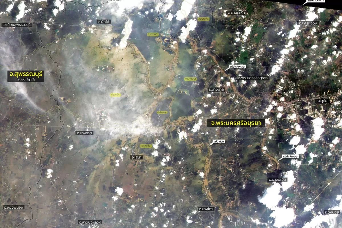
New satellite images show widespread fooding across four central provinces in Thailand, affecting 813,817 rai (1,300 square kilometres) of land, mostly low-lying agricultural areas and riverside communities, according to the Geo-Informatics and Space Technology Development Agency (Gistda).
The high-resolution images released on Thursday from the THEOS-1 satellite clearly show inundated areas in Ayutthaya and parts of Ang Thong, Suphan Buri and Nakhon Pathom provinces.
Authorities are attempting to manage heavier than expected flooding this year, while also mitigating the impact on Bangkok. Residents of Ayutthaya in particular have criticised the government’s water management efforts, saying they are paying a high price to keep the capital dry.
Prime Minister Anutin Charnvirakul on Wednesday acknowledged the problem during a visit to the area, and said farmers and landowners would receive monthly compensation payments until their land was fully dried out.
According to Gistda, Ayutthaya has been hardest hit, with 405,067 rai submerged in 12 districts — Sena, Phak Hai, Bang Sai, Bang Sai, Bang Ban, Lat Bua Luang, Bang Pa Han, Bang Pa-in, Nakhon Luang, Phra Nakhon Si Ayutthaya, Ban Phraek and Wang Noi.
In Ang Thong, about 2,932 rai in Pa Mok district was flooded.
Suphan Buri recorded flooding on 323,144 rai in Bang Pla Ma, Song Phi Nong and Muang districts.
In Nakhon Pathom, flooding has ravaged Bang Len district, affecting 82,674 rai.
Most of the affected areas were agricultural zones and residential communities located along major and secondary riverbanks and parts of key transport routes.
THEOS-1 imagery can also distinguish different types of floodwater: brown-tinted areas indicate newly flooded areas with sediment, while darker tones show long-standing inundation.
Gistda said that satellite data helped confirm and clarify the actual extent of flood damage, showing that the impacts extend beyond riverside areas into many communities in the four provinces.
The agency, under the Ministry of Higher Education, Science, Research and Innovation, said it was ready to provide space-based data and expertise to support flood and disaster management.
Gistda has also adjusted its satellite signal reception plans to monitor and analyse flood-prone areas continuously.